
Callum
Four days to go!
We’re almost at the end of the Via Dinarica, but, as if to give us one final challenge, this last section of trail goes from valley to valley, climbing up and down the ridges that separate them. If you imagine that you’ve dragged a garden rake through some sand, and then an ant walks perpendicular to the furrows, you might get some sense of what this section is like. We are the ant.
So it’s pretty much a mountain a day around here.
After spending an illegal night camping on Albanian soil, we woke up on the guest house lawn. Breakfast wasn’t until 8, so we packed leisurely, enjoying the sounds of Lepushë waking up. As a newly converted tourist town, Lepushë’s morning’s are filled by the sounds of both shepherds and tour buses, pigs and cyclists.
When we did get round to eating breakfast, I couldn’t help but notice that our vegetarian meal differed from the neighbouring Swedish couple’s only by the absence of meat, making ours significantly smaller. Still, as usual, there was plenty of bread, so I filled up to the brim. A full stomach goes a long way, I’ve found.
Then it was out the gate, up the hill, and into the village where we picked up the trail of white and red stripes. Huzzah! Unfortunately they led off in the wrong direction, and were labelled for some obscure and unknown peak. Not wishing to waste valuable energy, we instead wasted valuable time wandering around the village to see if we could find a track that better matched our map, but to no avail. Eventually we ran into a triangle of local men who, once they deciphered our butchered pronunciation of “Gusinje”, pointed us back in the direction of the dots, emphasising the ‘upness’ of the route with some fairly dramatic gestures. Ah, well, pays to be sure, right?
The reason why time was valuable today, is due, as usual, to the stressful bureaucracy of border crossings. The plan was to cross from the Albanian town of Lepushë to the Montenegrin town of Gusinje, in which we could catch a bus to the larger town of Plav. In Plav there is a Border Police unit who can hopefully give us the permit to cross into Albania (or rather, back to Albania, but we won’t tell them that), which we will pick up, before busing back to Gusinje tomorrow from where we will continue to walk. Simple, right?
Unfortunately the last bus from Gusinje to Plav leaves at 4:45 pm, so we had to be there before then; thus the rush to get moving.
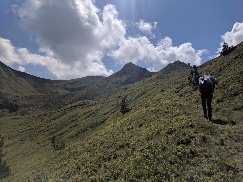
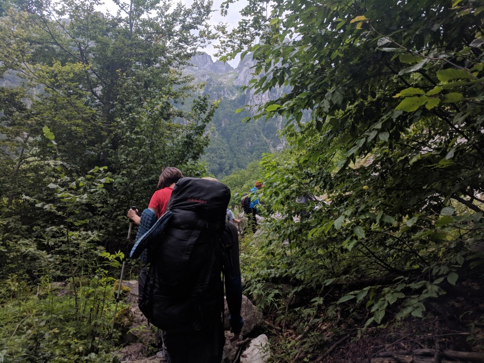
And so headed we up the hill, following an old pack route that felt remarkable similar to the one we took yesterday out of Vermosh. I couldn’t see the ridge above us, so I tracked our progress (or lack thereof) against the mountains on the other side of the valley. It was a steep and overused path, but a few streams and springs provided nice spots to pause and check if the houses below looked any smaller yet. Usually they didn’t.

The green pastures heading up from Lepushë towards Maja Vajush (also known as Mount Talijanka).
Eventually, after climbing about 700 m into the sky, the track disappeared into a broad mountain field, with a final, steep ridge a few hundred metres ahead. Huh, almost exactly the same geography as yesterday, right down to the scattered livestock and little shepherd’s settlement adorning the slopes.
We began trudging our way towards the steep ridge line on the horizon. As we drew closer, Kris called back, “Hey, I think there’s some people up there! Yeah, they’re definitely moving… There’s heaps of them!”
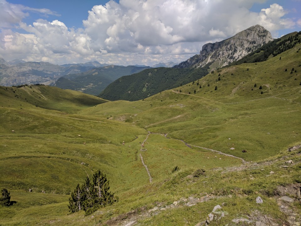
My sightly myopic eyes took a little longer to make them out, but eventually I saw the tiny silhouettes moving in long clusters along the ridge. There must have been dozens of them – a tour bus or two we decided. Suddenly I felt a whole lot more watched. My morning energy was more or less drained, so we made slow progress towards the ridge, stopping occasionally to snack on the wild blueberries adorning the slopes. I wanted to call out to the omnipotent silhouettes, “It’s steeper than it looks!” though I doubt many of them actually noticed us.
The slow trudge towards the ridge.
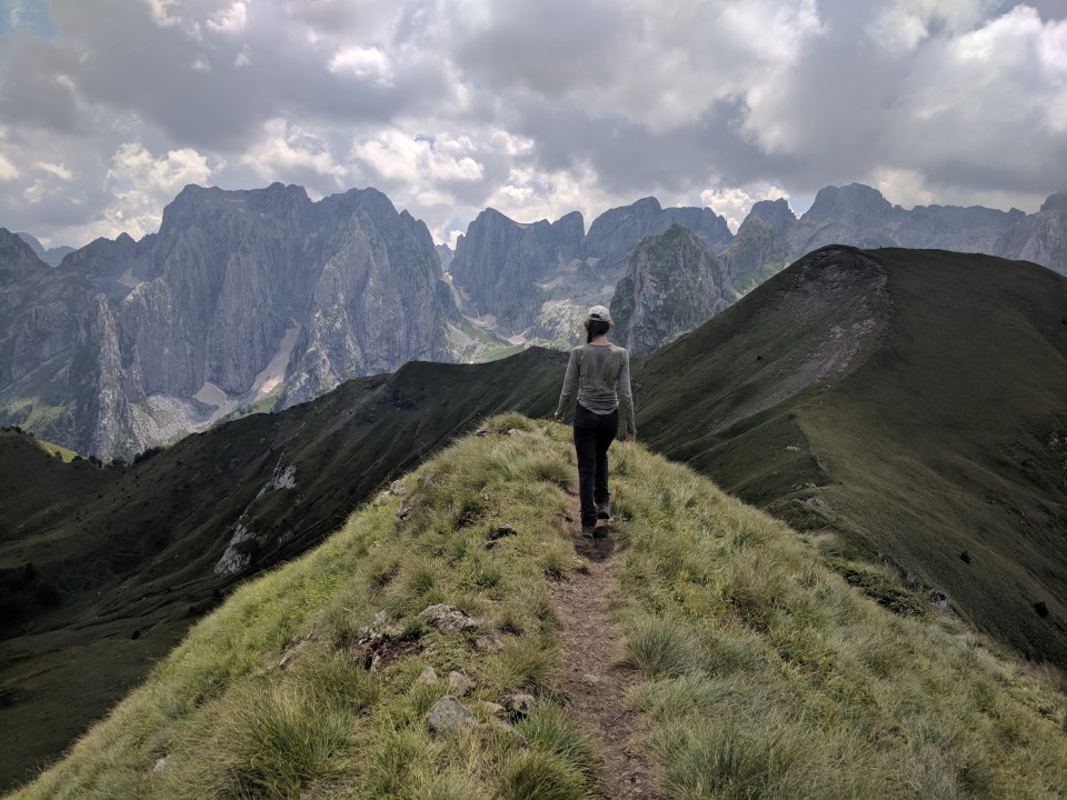
When we finally crawled into the ridge, it was like peeking behind a curtain. Before us lay the immense forest of limestone peaks that were Albania’s Accursed Mountains; looking behind we could see the fertile Albanian bowl through which we’d walked. A tiny sliver of Montenegro lay between us and those mountains. It was a border between two countries, but also two geographies.
Looking back at Albania – our last view of the country… Until tomorrow.
The ridge top view of (mainly) Albania. Luckily we don’t climb these particular peaks.
Stepping over that ridge was also a step back on to the tourist circuit. It turns out that on one day each year, all the local mountain clubs come and do a walk along this ridge in commemoration of a former member who died in a mountaineering accident. That day was today, and there was a good turn out. I don’t know how many people there were, but we must have seen well over a hundred. They moved in big groups, calling to each other across the valley, and whooping each time they reached a peak.
We mumbled hello as we passed the stream of hikers, and settled down for lunch on the peak of Maja Vajush, also known as Talijanka peak. With our hefty packs we stood out from all the day walkers, but everyone else looked the same to us, so we assumed they were all together. It was a little surprising then, when a young guy called out in a German accent, “Do you speak English?” This turned out to be Stephan who, believe it or not, was involved in the development of the Via Dinarica app. (I should mention that we’re once again off the official route, making this even more of a coincidence.) He was astonished that we were actually walking it, and pressed us for details about how it was. Apparently the Via Dinarica is being developed by just three guys who live in Sarajevo and are, reputedly, lovely.
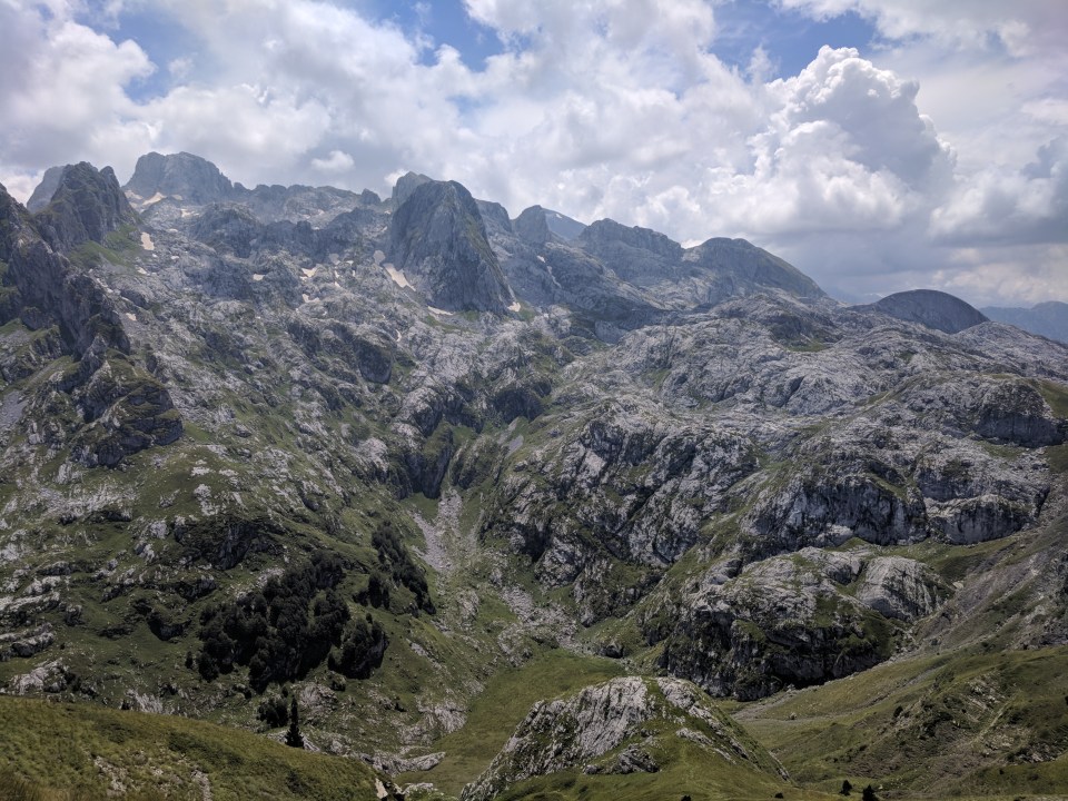
Albania’s suitably named Accursed Mountains.
We spent a good hour talking to Stephan, and his girlfriend Petra, and so by the time we started to make our way down the other side of the ridge it was approaching 2 pm, and our chances of walking the twelve kilometres to Gusinje before 4:45 seemed slim. Four kilometres an hour is a viable pace, but not on a mountain so swarming with people. We filed down the narrow track at a snails pace, with every minor obstacle turned into a Hilary’s step by the mechanics of walking in a crowd.
Conga line down the mountain.
When we finally made it down to the road, it had started to rain fairly heavily and I wasn’t particularly looking forward to an eight kilometre road walk. We still hadn’t eaten lunch, and the roads were busy with people leaving the National Park. My fears turned out to be grounded – it was a fairly miserable little walk, though nothing extraordinary; we’re yet to return to the hotties of the Croatian road walks.
Gusinje, when we arrived, was both deserted and busy at the same time. It was dusty and full of abandoned places, but also bursting with vegetable stalls, cafes and even street dancers. We didn’t spend much time there, however, as we immediately stumbled onto a bus leaving for Plav. This bus wasn’t listed on the timetable but tickets were one Euro, and so we rolled out of Gusinje before we even arrived. So far, so good.
Plav is a much larger town, situated on a lake that slowly becomes a marsh away from the town. We were dropped off conveniently right next to the police station. As we were walking over, Kris pulled out the phone. “I’ll just check the email to see that we’re in the right place.”
We weren’t. The border police were two kilometres away. By now it was 6 pm and we still hadn’t eaten lunch. So far, less good.
Nevertheless, we forced ourselves to trek over to the office, where we were told, by a smiling officer, to come back tomorrow. Sigh.
So, having passed beyond hunger, we trudged over to the guesthouse we’d hastily booked online an hour earlier. As the last cheap place in Plav, our room was everything you’d expect, and not. The room was a tiny partition with reclaimed particle board furniture and a concrete floor covered in carpet off-cuts. The garden outside, however, was stunning and clearly loved, and the building itself was an original Ottoman house. Kind of a contradictory place, but nice enough for us.
We dropped out bags, and headed out into nighttime Plav, on a mission for consolation food. Hopefully we can sort out the permits tomorrow.
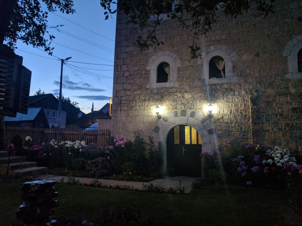
Our home for the night. We ended up spending most of our time right here, in the garden.
Details
Albania and Montenegro, Stage 43 (Part 2 of an alternate route via Lepushë and Mount Talijanka)
Start and end points: Lepushë to Gusinje, followed by a 10 minute bus to Plav
Approximate distance: 18.5 km
Villages: Lepushë – Grebaje – Dolja – Gusinje – Plav
Features: Maja Vajush (Taljanka/Talijanka peak) (2056 m) – Popadija (2057 m) – Grbaja Valley – Branko Kotlajić mountain hut – Restaurants in Grebaje (Restoran Maja Karanfil, Eco Katun Grebaje) – Markets in Gusinje – Supermarkets in Plav (Franca, others) – Border Police Station in Plav – Guesthouses in Plav
